English
 norsk
norskBlar i forfatter "Larsen, Yngvar"
Viser treff 1-8 av 8
-
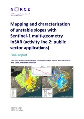
Mapping and characterization of unstable slopes with Sentinel-1 multi-geometry InSAR (activity line 2: public sector applications)
(Research report; Forskningsrapport, 2020)This is a high-level report that summarizes the main achievements and results of the research and development conducted in the project “Mapping and Characterization of unstable slopes with Sentinel-1 multi-geometry InSAR (activity line 2: public sector applications)”, where multi-geometry Sentinel-1 Synthetic Aperture Radar Interferometry (InSAR) is used for improving characterization of unstable ... -
Recent acceleration of a rock glacier complex, Ádjet, Norway, documented by 62 years of remote sensing observations
(Journal article; Tidsskriftartikkel; Peer reviewed, 2018-08-23)Recent acceleration of rock glaciers is well recognized in the European Alps, but similar behavior is hardly documented elsewhere. Also, the controlling factors are not fully understood. Here we provide evidence for acceleration of a rock glacier complex in northern Norway, from 62 years of remote sensing data. Average annual horizontal velocity measured by aerial feature tracking increased from ... -
Regional Morpho-Kinematic Inventory of Slope Movements in Northern Norway
(Journal article; Tidsskriftartikkel; Peer reviewed, 2021-11-25)Mountain slopes in periglacial environments are affected by frost- and gravity-driven processes that shape the landscape. Both rock glaciers and rockslides have been intensively inventoried worldwide. Although most inventories are traditionally based on morphologic criteria, kinematic approaches based on satellite remote sensing have more recently been used to identify moving landforms at the regional ... -
Relating 3D surface displacement from satellite- and ground-based InSAR to structures and geomorphology of the Jettan rockslide, northern Norway
(Journal article; Tidsskriftartikkel; Peer reviewed, 2017-12-13)This study combines remote sensing data from ground- and satellite-based radar to calculate 3D displacement vectors for the Jettan rockslide, Troms, northern Norway. Using 3D displacement vectors, aspect data and strain rates in conjunction with structure (foliation, faults, fractures), geomorphological elements (ridges, scarps, terraces, depressions), topography and borehole data, we identify zones ... -
Seasonal dynamics of a permafrost landscape, Adventdalen, Svalbard, investigated by InSAR
(Journal article; Tidsskriftartikkel; Peer reviewed, 2019-06-19)Nordenskiöld Land in Central Spitsbergen, Svalbard is characterized as a high latitude, high relief periglacial landscape with permafrost occurring both in mountains and lowlands. Freezing and thawing of the active layer causes seasonal frost heave and thaw subsidence, while permafrost-related mass-wasting processes induce downslope ground displacements on valley sides. Displacement rate varies ... -
Seasonal InSAR Displacements Documenting the Active Layer Freeze and Thaw Progression in Central-Western Spitsbergen, Svalbard
(Journal article; Tidsskriftartikkel; Peer reviewed, 2021-07-28)In permafrost areas, the active layer undergoes seasonal frost heave and thaw subsidence caused by ice formation and melting. The amplitude and timing of the ground displacement cycles depend on the climatic and ground conditions. Here we used Sentinel-1 Synthetic Aperture Radar Interferometry (InSAR) to document the seasonal displacement progression in three regions of Svalbard. We retrieved ... -
Subband Extraction Strategies in Ship Detection With the Subaperture Cross-Correlation Magnitude
(Journal article; Tidsskriftartikkel; Peer reviewed, 2012-01-27)The subaperture cross-correlation magnitude (SCM) has previously been proposed as a statistic that improves the contrast between small ship targets and the surrounding sea in synthetic-aperture-radar images. This preprocessing technique utilizes the fast decorrelation of open-water surface ripples on the scale of the SAR wavelength relative to coherent targets such as a ship. However, optimization ... -
Visualizing and interpreting surface displacement patterns on unstable slopes using multi-geometry satellite SAR interferometry (2D InSAR)
(Journal article; Tidsskriftartikkel; Peer reviewed, 2017-02-05)It is well known that satellite radar interferometry (InSAR) is capable of measuring surface displacement with a typical accuracy on the order of millimeters to centimeters. However, when the true deformation vector differs from the satellite line-of-sight (LOS), the sensitivity decreases and interpretation of InSAR deformationmeasurements becomes challenging. By combining displacement data ...